How City Riders Learn to Read Routes
Learn how to read city routes by combining stop names, landmarks, route diagrams and schedules, so you can identify the right service and follow it with confidence.
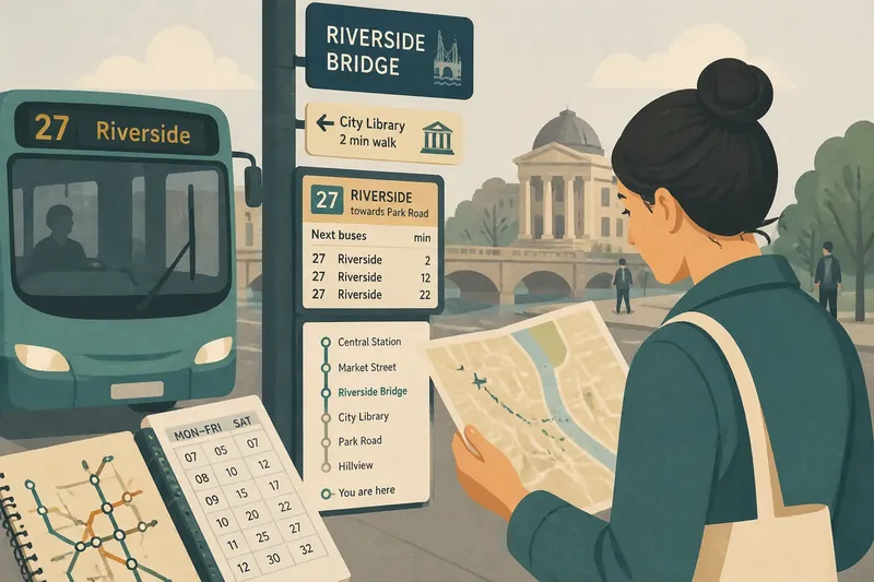
A stop name can place you on a route, but a street sign or landmark can show where you are standing. Learning how to read city routes means combining these clues rather than trusting one source to explain the whole journey.
There is no single story of how riders learned to find their way across cities. Local knowledge, spoken directions, signs and printed route information can all help, and their usefulness depends on what a passenger needs to know. A landmark helps with location; a route diagram shows connections; a schedule gives planned times. Each answers a different question.
Street landmarks
A bridge, public library or distinctive corner can help you recognise a stretch of a journey, especially when stop names are unfamiliar. The clue is strongest when you can connect it to a direction: the bus passes the library before turning towards the park, for instance.
Landmarks are less reliable when they are obscured, look similar to nearby buildings or have changed. Treat them as confirmation, not as the only evidence that you have reached the right stop. A street sign or stop label can add a more specific reference.
Spoken directions
A driver, another passenger or someone at a local shop may describe a route in terms that make sense to you: stay on until the river, then walk towards the station. Ask for a route number, the direction of travel and a visible clue. That gives you something to compare with signs and the view outside.
Local descriptions may use names that do not appear on official signs, and an instruction remembered later can lose an important detail. If the advice conflicts with the stop display or route information, pause and check before boarding or getting off.
Stop names
Stop names give passengers a shared reference for announcements, signs and journey plans. But a name may refer to a broad neighbourhood or to a building whose use has changed. Check the stop label and nearby street signs, especially when the destination is not directly beside the stop.
Say you need to reach a gallery beyond a stop called Museum Road. You check that the vehicle displays your route number and the correct direction, then compare the stop name with a street sign as you get off. The gallery is not visible, so you use a street map for the final walk. The result is a clear distinction between identifying the stop and locating the entrance.
Route diagrams
A route diagram shows the order of stops and where services connect. A single-route diagram is useful for following one line; a network diagram helps compare lines and find interchanges. Check the route number, direction and stop sequence before deciding where to change.
Diagrams simplify geography to make relationships easier to see. A line may be drawn straight despite bends in the road, and the spacing between stops may not reflect their physical distance. Use the diagram to understand the service, then switch to a street map or map app for walking directions.
Schedules and signs
A schedule lists planned departure or arrival times; an electronic display may show approaching services. Check that the information matches your stop, route and direction. A panel for the opposite side of the road may describe a different journey.
Service patterns can vary by time or day. Read the notice for the period you are travelling rather than relying on a timetable remembered from another occasion. The schedule can help you choose when to leave, but it cannot confirm your location by itself.
Which route clue should you use?
What does a route map tell you?
It shows a service’s stop sequence and connections, but may simplify the streets. Use a street map for exact walking directions.
How do I follow a route if stop names are unfamiliar?
Match the route number with its direction, then watch for a named stop or visible landmark. If those clues disagree, check the displayed service information before getting off.
How can I tell whether a schedule applies to my journey?
Check the stop, route, direction and service period shown on the timetable or display. If any of these do not match, find the information for the correct service before planning around its times.
Clues in combination
When you are unsure, make a decision from what you can observe rather than from memory alone:
- Stop location: If the stop name and street sign agree, use them together to confirm where you are; if they do not, check a map or ask for directions before boarding.
- Service identity: If both the route number and direction match your plan, board; if only the number matches, check the destination display or route diagram first.
- Next stop: If the announced stop matches your route plan, continue; if the announcement is unclear or unexpected, check the display or ask a passenger or driver.
- Connection: If the diagram shows your interchange on the service you are taking, follow that sequence; if it shows a different direction, identify the correct platform or stop before travelling.
- Departure time: If the schedule matches your stop, route and travel period, use it to plan; if one detail differs, consult the relevant timetable or live display.
- Final walk: If the destination is visible from the stop, follow the street signs; if it is not, use a street map or map app rather than estimating from a simplified route diagram.
How to read city routes is less a matter of memorising every stop than of matching the right clue to the question at hand. Before leaving a vehicle, check the next stop against a second cue—a sign, a display or a recognisable feature—so a familiar name does not have to carry the whole journey.